-
Shop our Range
▼
-
Deals & Promotions
►
Featured Deals & Promotions
-
Fishing
►
Featured Fishing Categories
-
Boating
►
Featured Boating Categories
-
Marine Electronics
►
Featured Marine Electronics Categories
-
Diving & Snorkeling
►
Featured Diving & Snorkeling Categories
-
Watersports
►
Featured Watersports Categories
-
Apparel
►
Featured Apparel Categories
-
Camping & Hiking
►
Featured Camping & Hiking Categories
-
RV & Motorhomes
►
Featured RV & Motorhomes Categories
-
Hunting
►
Featured Hunting Categories
-
Shop By Brand
►
-
Deals & Promotions
►
-
How Can We Help You?
Give Us A Call 0800 633 257
Or get us to call you...
Note: Our shop is open Monday to Friday 8:00am to 6:00pm, Saturday 8:00am to 5:00pm and Sunday 10:00am to 4:00pm (closed public holidays).
- Fast Shipping with CourierPost 95% orders shipped same day*
- Full Warranty We'll refund, repair or replace your item*
- No Worries Returns Submit a request, receive our return label & ship it back
- Lowest Price Guarantee Find a lower price, we'll match it or we can do better!
- Massive Range 21,000+ products in stock ready to ship!


- Details
-
Details

This Imray-Iolaire waterproof chart of St. Eustatius to the St. Christopher islands, part of the Leeward Island group in the Caribbean Sea, features large-scale insets and detailed information of Saba Island and Fort Baai on Saba, Montserrat Island and Plymouth on Montserrat, Basseterre Bay on St. Kitts Island, The Narrows, and Oranjebaai on St. Eustatius Island. The chart is printed in color and uses official surveys and notes based on local knowledge.
Features:- Printed in color on treated, water-resistant paper
- Folded for efficient storage
- Includes protective plastic sleeve
Specifications:- Length: 34.5 in (87.63 cm)
- Width: 25 in (63.5 cm)
- Height: 0.1 in (0.25 cm)
- Dimensions: 25' x 35 1/2' (640 x 900 cm)
- Weight: 0.3 lb (0.25 cm)
- UPC Code: 9781846234569
- HTS Code: 4905.99.0000
Products You Recently Viewed
-
Imray St. Eustatius/St. Christopher/Nevis/Monteserrat and Saba Chart
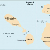 ONLY $99.99
Ships Jun 12 - Jul 8